If you’re searching for reliable guidance on exploring remote hiking trails worldwide, you’re likely looking for more than inspiration—you want practical knowledge that keeps you prepared, confident, and safe. This article delivers exactly that. We break down essential wilderness skills, smart survival tactics, dependable gear recommendations, and trail navigation fundamentals so you can venture farther with clarity and control.
Exploring isolated terrain demands more than enthusiasm. It requires an understanding of changing environments, risk management, and equipment that performs when conditions turn unpredictable. Drawing on field-tested outdoor practices, current backcountry research, and real-world trail analysis, this guide focuses on actionable insights you can apply immediately.
Whether you’re planning your first off-grid trek or refining your advanced backcountry strategy, you’ll find practical steps to assess terrain, prepare effectively, and move through wild landscapes with confidence. Let’s get you ready for the trail ahead.
Beyond the Crowded Peaks
If trailhead parking lots feel like concert venues, you’re not alone. Overcrowding in flagship parks has surged in recent years (National Park Service visitation reports), pushing solitude seekers elsewhere.
The solution isn’t quitting hiking—it’s learning how to access remote hiking trails worldwide with confidence.
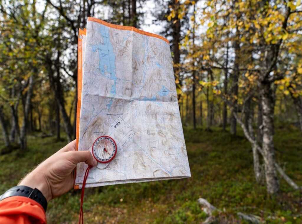
Start with topographic map literacy—the ability to read contour lines, water sources, and elevation gain. Carry a satellite communicator, paper backups, and layered insulation (weather flips fast). Research local regulations, seasonal hazards, and bailout routes before departure.
Pro tip: plan midweek starts and shoulder-season trips for quieter miles.
Adventure favors the prepared.
The Accursed Mountains, Albania: Europe’s Last Wilderness Frontier
The Accursed Mountains—known locally as the Albanian Alps—rise in jagged limestone spires that feel torn from the earth rather than gently shaped by it. Deep glacial valleys funnel cold air through beech forests, and in Theth, the iconic Blue Eye forms a startling turquoise pool fed by snowmelt. Unlike the manicured trails and cable cars of Switzerland, this landscape remains defiantly raw (think Game of Thrones without the CGI polish). In fact, Albania welcomed roughly 10 million tourists in 2023, according to the Albanian Ministry of Tourism, yet only a fraction venture into these northern ranges—evidence of how untouched this region remains.
Why so overlooked? Until the early 2000s, infrastructure in northern Albania was minimal; paved access roads to Theth were only completed in recent years. The World Bank has documented Albania’s late tourism development compared to Western Europe, which inadvertently preserved its cultural traditions and biodiversity. Isolation became conservation by default.
The crown jewel trek is the Valbona to Theth pass, a 17-kilometer route gaining roughly 1,000 meters in elevation. Trail markings can be inconsistent, and rescue infrastructure is limited, so reliable offline maps like AllTrails Pro or Gaia GPS are essential (don’t count on cell service). This is true of remote hiking trails worldwide, but here the margin for error feels slimmer.
Wilderness skills aren’t optional. Potable water comes from natural springs—purification tablets or filters are critical. Pack lightweight, high-energy foods; resupply points are scarce beyond guesthouses. Pro tip: weigh your pack before departure—every extra kilogram feels doubled on the ascent.
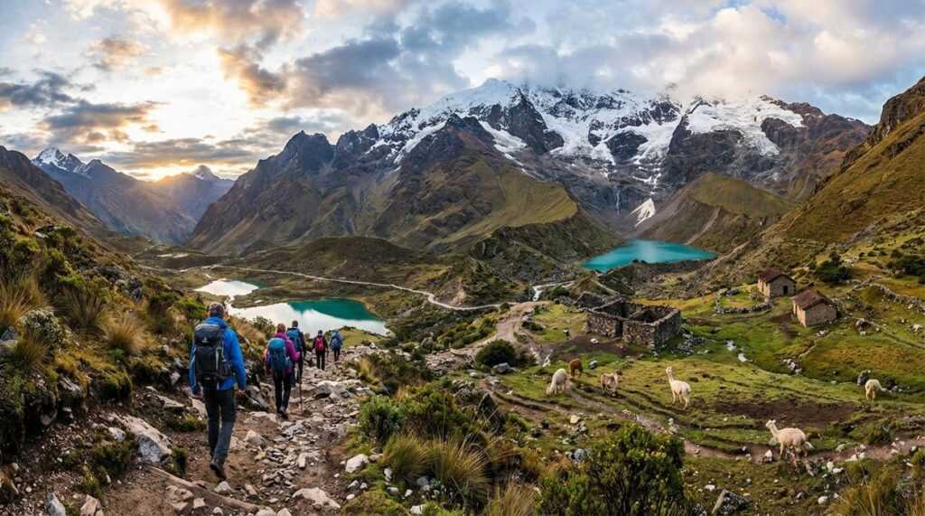
Salkantay Trek, Peru: The Wilder Alternative to the Inca Trail
The Salkantay Trek is what happens when you trade crowds for raw Andes drama. Instead of shuffling along the permit-locked Inca Trail, you climb to Salkantay Pass at 15,090 ft (4,600 m), where glaciers loom overhead and the air feels razor-thin (because it is). High altitude—generally defined as anything above 8,000 ft—can trigger altitude sickness, which affects up to 25% of travelers sleeping above 8,000–10,000 ft (CDC). Acclimatization isn’t optional; it’s survival.
Then the landscape flips. You descend into cloud forest, coffee farms, and humid jungle—like trekking through three climate zones in one long weekend. It’s a living lesson in unusual wildlife adaptations found in extreme environments.
Why Choose Salkantay?
Some argue the Inca Trail is more “authentic” because it ends at the Sun Gate. Fair. But Salkantay offers something rarer: freedom. No lottery permits. No yearlong planning. If weather and fitness align, you go. That flexibility alone makes it one of the best remote hiking trails worldwide.
Here’s what I recommend:
- Layer aggressively. Temperatures swing from below freezing at the pass to tropical heat below.
- Carry a GPS beacon or satellite messenger. Weather changes fast, and trails can blur under snow.
- Use a 0°F/-18°C rated sleeping bag and waterproof tent. Non-negotiable.
Pro tip: Start summit day before dawn for firmer ground and clearer skies.
Yes, it’s tougher. Yes, it’s less manicured. But if you want the Andes unfiltered—think “Into the Wild,” minus the poor decisions—Salkantay is the smarter choice.
The Laugavegur Trail, Iceland: A Geothermal Wonderland Off-Season
The Laugavegur Trail doesn’t look real. Rhyolite mountains streaked in rust, ochre, and moss-green rise above black obsidian deserts. Steam curls from geothermal vents. Ice caves glow electric blue beneath ancient glaciers. It feels less like Europe and more like a film set for Dune (minus the sandworms). These volcanic colors come from mineral-rich rhyolite formed by eruptions over the last 10,000 years, part of Iceland’s active Mid-Atlantic Rift system (Icelandic Met Office).
Most hikers tackle the 55-kilometer route in July and August, when more than 10,000 people traverse it each season (Iceland Touring Association). But the true solitude? Late May and early September. Visitor numbers drop sharply, offering the kind of isolation usually reserved for remote hiking trails worldwide.
Skeptics argue summer is safer—and they’re right. Shoulder season demands advanced navigation. Snowfields can bury trail markers. Seasonal footbridges may not yet span glacial rivers. A GPS device is mandatory, not optional, because cairns disappear under fresh snow. Route-finding skills—map, compass, terrain reading—are essential.
Shoulder-season challenges include:
- Unbridged river crossings with strong glacial runoff
- Winds exceeding 20 m/s (recorded regularly in highlands)
- Rapid weather swings from sun to sleet in hours
Survival hinges on preparation. A 4-season tent with reinforced poles is critical against katabatic winds. The hut-to-hut system offers refuge, but even off-season spots must be booked months ahead due to limited capacity.
Pro tip: Start river crossings early in the day when meltwater levels are lower. Solitude here isn’t given—it’s earned.
The Preparation Gap
Breathtaking solitude isn’t reserved for elite explorers; it’s available to anyone willing to choose preparation over convenience. Overcrowded hotspots offer marked paths and food trucks. In contrast, remote hiking trails worldwide demand self-sufficiency, layered planning, and practiced wilderness skills. One promises ease; the other promises depth.
So what separates a dreamer from a departure date? First, mindset. A casual weekend hiker hopes the weather holds. A prepared trekker studies forecasts, maps contingency routes, and packs redundancies (because hope is not a strategy). Navigation app versus map-and-compass backup. Ultralight tarp versus weatherproof shelter. Good enough versus field-tested.
Admittedly, some argue that overplanning kills spontaneity. Yet the opposite is true: solid preparation creates freedom. When your gear is reliable, you can focus on horizon, not what-ifs.
Start today. Audit your pack. Test your navigation system. Pitch your shelter in the rain. The expedition begins long before the trailhead.
Your Next Step Toward the Wild
You set out to learn how to prepare smarter, travel safer, and explore farther. Now you have the knowledge to navigate tougher terrain, choose reliable gear, and handle the unexpected with confidence.
But knowing isn’t the same as doing.
Every year, hikers underestimate conditions, overestimate their stamina, or head out unprepared for remote hiking trails worldwide. The result? Cut trips short, unnecessary risks, and missed experiences you’ve waited months—or years—to have.
Take action now. Put these strategies into practice. Upgrade the gear that’s holding you back. Refine your navigation skills before your next expedition.
If you’re serious about pushing deeper into the wilderness without second‑guessing every step, rely on guidance trusted by thousands of dedicated outdoor enthusiasts who demand proven tactics and no‑nonsense gear insights.
Plan smarter. Train harder. Step onto your next trail fully prepared—and make it your strongest adventure yet.
 Ask Joseph Jasperincons how they got into curious explorations and you'll probably get a longer answer than you expected. The short version: Joseph started doing it, got genuinely hooked, and at some point realized they had accumulated enough hard-won knowledge that it would be a waste not to share it. So they started writing.
What makes Joseph worth reading is that they skips the obvious stuff. Nobody needs another surface-level take on Curious Explorations, Frontier Findings, Hid Terrain Expedition Techniques. What readers actually want is the nuance — the part that only becomes clear after you've made a few mistakes and figured out why. That's the territory Joseph operates in. The writing is direct, occasionally blunt, and always built around what's actually true rather than what sounds good in an article. They has little patience for filler, which means they's pieces tend to be denser with real information than the average post on the same subject.
Joseph doesn't write to impress anyone. They writes because they has things to say that they genuinely thinks people should hear. That motivation — basic as it sounds — produces something noticeably different from content written for clicks or word count. Readers pick up on it. The comments on Joseph's work tend to reflect that.
Ask Joseph Jasperincons how they got into curious explorations and you'll probably get a longer answer than you expected. The short version: Joseph started doing it, got genuinely hooked, and at some point realized they had accumulated enough hard-won knowledge that it would be a waste not to share it. So they started writing.
What makes Joseph worth reading is that they skips the obvious stuff. Nobody needs another surface-level take on Curious Explorations, Frontier Findings, Hid Terrain Expedition Techniques. What readers actually want is the nuance — the part that only becomes clear after you've made a few mistakes and figured out why. That's the territory Joseph operates in. The writing is direct, occasionally blunt, and always built around what's actually true rather than what sounds good in an article. They has little patience for filler, which means they's pieces tend to be denser with real information than the average post on the same subject.
Joseph doesn't write to impress anyone. They writes because they has things to say that they genuinely thinks people should hear. That motivation — basic as it sounds — produces something noticeably different from content written for clicks or word count. Readers pick up on it. The comments on Joseph's work tend to reflect that.